
Sundarban : The most amazing place of Bangladesh


The Sundarbans is the largest single block of tidal halophytic mangrove forest in the world.[1] The name Sundarban can be literally translated as "beautiful jungle" or "beautiful forest" in the Bengali language (Sundar, "beautiful" and ban, "forest" or "jungle"). The name may have been derived from the Sundari trees that are found in Sundarbans in large numbers. Alternatively, it has been proposed that the name is a corruption of Samudraban (Bengali: ???????? Shomudrobôn "Sea Forest") or Chandra-bandhe (name of a primitive tribe). But the generally accepted view is the one associated with Sundari trees.
The forest lies in the vast delta on the Bay of Bengal formed by the confluence of the Ganges, Brahmaputra and Meghna rivers across southern Bangladesh and West Bengal, India. The seasonally-flooded Sundarbans freshwater swamp forests lie inland from the mangrove forests on the coastal fringe. The forest covers 10,000 sq.km. of which about 6,000 are in Bangladesh.[2] It became inscribed as a UNESCO world heritage site in 1997, but while the Bangladeshi and Indian portions constitute the same continuous ecotope, these are separately listed in the UNESCO world heritage list as the Sundarbans and Sundarbans National Park, respectively. The Sundarbans is intersected by a complex network of tidal waterways, mudflats and small islands of salt-tolerant mangrove forests. The area is known for the eponymous Royal Bengal Tiger (Panthera tigris tigris), as well as numerous fauna including species of birds, spotted deer, crocodiles and snakes. The fertile soils of the delta have been subject to intensive human use for centuries, and the ecoregion has been mostly converted to intensive agriculture, with few enclaves of forest remaining. The remaining forests, together with the Sundarbans mangroves, are important habitat for the endangered tiger.

Additionally, the Sundarbans serves a crucial function as a protective barrier for the millions of inhabitants in and around Kolkata (Calcutta) against the floods that result from the cyclones that are a regular occurrence on this coast.
Contents
[hide]
* 1 History
* 2 Physiography
o 2.1 Ecoregions
o 2.2 Sanctuaries in Bangladesh
o 2.3 Climate change impact
* 3 Flora
* 4 Fauna
o 4.1 Predators
o 4.2 Avifauna
o 4.3 Aqua fauna
Historty

The history of the area can be traced back to 200–300 AD. A ruin of a city built by Chand Sadagar has been found in the Baghmara Forest Block. During the Mughal period, local kings leased the forests of the Sundarbans to residents. In this period, Raja Basanta Rai and his nephew took refuge in the Sundarbans from the advancing armies of Emperor Akbar.[3] Many of the buildings which were built by them later fell to hands of Portuguese pirates, salt smugglers and dacoits in the 17th century. Evidence of the fact can be traced from the ruins at Netidhopani and other places scattered all over Sundarbans.[4] The legal status of the forests underwent a series of changes, including the distinction of being the first mangrove forest in the world to be brought under scientific management. The area was mapped by the Surveyor General as early as 1764 following soon after proprietary rights were obtained from the Mughal Emperor Alamgir II by the East India Company in 1757. Systematic management of this forest tract started in the 1860s after the establishment of a Forest Department in the Province of Bengal, in India.[5]
The first Forest Management Division to have jurisdiction over the Sundarbans was established in 1869. In 1875 a large portion of the mangrove forests was declared as reserved forests in 1875–76 under the Forest Act, 1865 (Act VIII of 1865). The remaining portions of forests was declared as reserve forest the following year and the forest, which was so far was administered by the civil administration district, was placed under the control of the Forest Department. A Forest Division, which is the basic forest management and administration unit, was created in 1879 with the headquarter in Khulna. The first management plan was written for the period 1893–98.[6][7]
In 1911, it was described as a tract of waste country which had never been surveyed, nor had the census been extended to it. It then stretched for about 165 miles (266 km) from the mouth of the Hugli to the mouth of the Meghna and was bordered inland by the three settled districts of the 24 Parganas, Khulna and Backergunje. The total area (including water) was estimated at 6,526 square miles (16,902 km2). It was a water-logged jungle, in which tigers and other wild beasts abounded. Attempts at reclamation had not been very successful. The characteristic tree was the sundari (Heritiera littoralis), from which the name of the tract had probably been derived. It yields a hard wood, used for building, and for making boats, furniture, etc. The Sundarbans were everywhere intersected by river channels and creeks, some of which afforded water communication between Calcutta and the Brahmaputra Valley, both for steamers and for native boats.
Physiography
The mangrove-dominated Ganges Delta – the Sundarbans – is a complex ecosystem comprising one of the three largest single tract of mangrove forests of the world. Shared between two neighbouring countries, Bangladesh and India, the larger part (62%)is situated in the southwest corner of Bangladesh. To the south the forest meets the Bay of Bengal; to the east it is bordered by the Baleswar River and to the north there is a sharp interface with intensively cultivated land. The natural drainage in the upstream areas, other than the main river channels, is everywhere impeded by extensive embankments and polders. The Sundarbans was originally measured (about 200 years ago) to be of about 16,700 km². Now it has dwindled to about 1/3 of the original size. The total land area today is 4,143 km² (including exposed sandbars: 42 km²) and the remaining water area of 1,874 km² encompasses rivers, small streams and canals. Rivers in the Sundarbans are meeting places of salt water and freshwater. Thus, it is a region of transition between the freshwater of the rivers originating from the Ganges and the saline water of the Bay of Bengal (Wahid et al., 2002).
The Sundarbans along the Bay of Bengal has evolved over the millennia through natural deposition of upstream sediments accompanied by intertidal segregation. The physiography is dominated by deltaic formations that include innumerable drainage lines associated with surface and subaqueous levees, splays and tidal flats. There are also marginal marshes above mean tide level, tidal sandbars and islands with their networks of tidal channels, subaqueous distal bars and proto-delta clays and silt sediments. The Sundarbans' floor varies from 0.9 m to 2.11 m above sea level.[8]
Biotic factors here play a significant role in physical coastal evolution and for wildlife a variety of habitats have developed including beaches, estuaries, permanent and semi-permanent swamps, tidal flats, tidal creeks, coastal dunes, back dunes and levees. The mangrove vegetation itself assists in the formation of new landmass and the intertidal vegetation plays an important role in swamp morphology. The activities of mangrove fauna in the intertidal mudflats develop micromorphological features that trap and hold sediments to create a substratum for mangrove seeds. The morphology and evolution of the eolian dunes is controlled by an abundance of xerophytic and halophytic plants. Creepers and grasses and sedges stabilizes sand dunes and uncompacted sediments. The Sunderbans mudflats (Banerjee, 1998) are found at the estuary and on the deltaic islands where low velocity of river and tidal current occurs. The flats are exposed in low tides and submerged in high tides, thus being changed morphologically even in one tidal cycle. The interiorparts of the mudflats are magnificent home of luxuriant mangroves.
Ecoregions
Sundarbans features two ecoregions — "Sundarbans freshwater swamp forests" (IM0162) and "Sundarbans mangroves" (IM1406).[9]

The Sundarbans freshwater swamp forests are a tropical moist broadleaf forest ecoregion of India and Bangladesh. It represents the brackish swamp forests that lie behind the Sundarbans Mangroves where the salinity is more pronounced. The freshwater ecoregion is an area where the water is only slightly brackish and becomes quite fresh during the rainy season, when the freshwater plumes from the Ganges and Brahmaputra rivers push the intruding salt water out and also bring a deposit of silt. It covers an area of 14,600 square kilometers (5,600 square miles) of the vast Ganges-Brahmaputra Delta, extending from India's West Bengal state into western Bangladesh. The Sundarbans freshwater swamp forests lie between the upland Lower Gangetic plains moist deciduous forests and the brackish-water Sundarbans mangroves bordering the Bay of Bengal.[10]
This ecoregion is nearly extinct, the victim of large-scale clearing and settlement to support one of the densest human populations in Asia. Hundreds of years of habitation and exploitation by one of the world's densest human populations have exacted a heavy toll of this ecoregion's habitat and biodiversity. There are two protected areas — Narendrapur (110 km2) and Ata Danga Baor (20 km2) that cover a mere 130 km2 of the ecoregion. Habitat loss in this ecoregion is so extensive, and the remaining habitat is so fragmented, that it is difficult to ascertain the composition of the original vegetation of this ecoregion. According to Champion and Seth (1968), the freshwater swamp forests are characterized by Heritiera minor, Xylocarpus molluccensis, Bruguiera conjugata, Sonneratia apetala, Avicennia officinalis, and Sonneratia caseolaris, with Pandanus tectorius, Hibiscus tiliaceus, and Nipa fruticans along the fringing banks.[10]
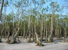
The Sundarbans Mangroves ecoregion on the coast forms the seaward fringe of the delta and is the world's largest mangrove ecosystem, with 20,400 square kilometers (7,900 square miles) of area covered. The dominant mangrove species Heritiera fomes, locally known as sundri or sundari, is the tree for which the Sundarbans are thought to be named. Mangrove forests are not home to a great variety of plants. They have a thick canopy and the undergrowth is mostly seedlings of the mangrove trees. As well as the sundari other species that make up the forest include Avicennia spp., Xylocarpus mekongensis, Xylocarpus granatum, Sonneratia apetala, Bruguiera gymnorrhiza, Cereops decandra, Aegiceras corniculatum, Rhizophora mucronata, and Nypa fruticans palms.[11]
The Sundarbans area is one of the most densely populated in the world and the population is increasing, as a result half of this ecoregion's mangrove forests have been cut down to supply fuelwood and other natural resources. Despite the intense and large-scale exploitation, this still is one of the largest contiguous areas of mangroves in the world. Another threat comes from deforestation and water diversion from the rivers inland which causes far more silt to be brought to the estuary, clogging up the waterways. Protected areas cover 15% of the Sundarbans mangroves including Sundarbans National Park and Sajnakhali Wildlife Sanctuary, Halliday Island and Lothian Island Wildlife Sanctuary in West Bengal and Sundarbans East, Char Kukri-Mukri, Sundarbans South and Sundarbans West Wildlife Sanctuaries in Bangladesh.[11]
Sanctuaries in Bangladesh
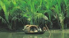
The Bangladesh part of the Sundarbans is estimated to be about 4,110 km², of which about 1,700 km² is occupied by waterbodies in the forms of river, canals and creeks of width varying from a few meters to several kilometers. The interconnected network of waterways makes almost every corner of the forest accessible by boat. The forest lies under two forest divisions, and four administrative ranges viz Chandpai, Sarankhola, Khulna, and Burigoalini,Satkhira and has sixteen forest stations. It is further divided into fifty-five compartments and nine blocks.[1]
A new Khulna Forest Circle to preserve the forest was created in 1993 and a Conservator of Forests has been posted. The direct administrative head of the Division is the Divisional Forest Officer who is also based at Khulna. The Divisional Forest Officer has a number of professional, subprofessional and support staff and logistic supports for the implementation of necessary management and administrative activities. The basic unit of management is the compartment. There are 55 compartments in four Forest Ranges and these are clearly demarcated mainly by natural features such as rives, canals and creeks.
There are three wildlife sanctuaries established in 1977 under the Bangladesh Wildlife (Preservation) Order, 1973 (P.O. 23 of 1973). These are:
1. Sundarbans East Wildlife Sanctuary: Extends over an area of 31,227 ha. Freshwater and Sundri (Heritiera fomes) dominate interspersed with Gewa (Excoecaria agallocha) and Passur (Xylocarpus mekongensis) with Kankra (Bruguiera gymnorrhiza) occurring in areas subject to more frequent flooding. There is an understory of Shingra (Cynometra ramiflora) where, soils are drier and Amur (Amoora cucullata) in wetter areas and Goran (Ceriops decandra) in more saline places. Nypa palm (Nypa fruticans) widespread along drainage lines.
2. Sundarbans South Wildlife Sanctuary: Extends over an area of 36,970 ha. There is evidently the greatest seasonal variation in salinity levels and possibly represents an area of relatively longer duration of moderate salinity where Gewa is the dominant woody species. It is often mixed with Sundri, which is able to displace in circumstances such as artificially opened canopies where Sundri does not regenerate as effectively. It is also frequently associated with a dense understory of Goran and sometimes Passur.
3. Sundarbans West Wildlife Sanctuary: Extends over an area of 71,502 ha. Includes areas which support sparse Gewa and dense stands of Goran and discontinuous patches of Hantal palm (Phoenix paludosa) on drier ground and river banks and levees.
Climate change impact
The physical development processes along the coast are influenced by a multitude of factors, comprising wave motions, micro and macro-tidal cycles and long shore currents typical to the coastal tract. The shore currents vary greatly along with the monsoon. These are also affected by cyclonic action. Erosion and accretion through these forces maintains varying levels, as yet not properly measured, of physiographic change whilst the mangrove vegetation itself provides a remarkable stability to the entire system. During each monsoon season almost all the Bengal Delta is submerged, much of it for half a year. The sediment of the lower delta plain is primarily advected inland by monsoonal coastal setup and cyclonic events. One of the greatest challenges people living on the Ganges Delta may face in coming years is the threat of rising sea levels caused mostly by subsidence in the region and partly by climate change.
In many of the Indian mangrove wetlands, freshwater reaching the mangroves was considerably reduced from the late 19th century due to diversion of freshwater in the upstream area. Also, the Bengal Basin is slowly tilting towards the east due to neo-tectonic movement, forcing greater freshwater input to the Bangladesh Sundarbans. As a result, the salinity of the Bangladesh Sundarbans is much lower than that of the Indian Sundarbans. A 1990 study noted that there "is no evidence that environmental degradation in the Himalayas or a 'greenhouse' induced rise in sea level have aggravated floods in Bangladesh"; however, a 2007 report by UNESCO, "Case Studies on Climate Change and World Heritage" has stated that an anthropogenic 45-cm rise in sea level (likely by the end of the 21st century, according to the Intergovernmental Panel on Climate Change), combined with other forms of anthropogenic stress on the Sundarbans, could lead to the destruction of 75% of the Sundarbans mangroves.[12] Already, Lohachara Island and New Moore Island/South Talpatti Island have disappeared under the sea, and Ghoramara Island is half submerged.[13]

Flora
The Sundarbans flora is characterized by the abundance of Heritiera fomes, Excoecaria agallocha, Ceriops decandra and Sonneratia apetala. A total 245 genera and 334 plant species were recorded by David Prain in 1903.[14] Since Prain’s report there have been considerable changes in the status of various mangrove species and taxonomic revision of the man-grove flora.[15] However, very little exploration of the botanical nature of the Sundarbans has been made to keep up with these changes. Whilst most of the mangroves in other parts of the world are characterized by members of the Rhizophoraceae, Avicenneaceae or Laganculariaceae, the mangroves of Bangladesh are dominated by the Sterculiaceae and Euphorbiaceae.[6]
The Bangladesh mangrove vegetation of the Sundarbans differs greatly from other non-deltaic coastal mangrove forest and upland forests associations. Unlike the former, the Rhizophoraceae are of minor importance. Differences in vegetation have been explained in terms of freshwater and low salinity influences in the Northeast and variations in drainage and siltation. The Sundarbans has been classified as a moist tropical forest demonstrating a whole mosaic of seres, comprising primary colonization on new accretions to more mature beach forests, often conspicuously dominated by Keora (Sonneratia apetala) and tidal forests. Historically three principal vegetation types have been recognized in broad correlation with varying degrees of water salinity, freshwater flushing and physiography and which are represented in the wildlife sanctuaries:
Sundari and Gewa occur prominently throughout the area with discontinuous distribution of Dhundul (Xylocarpus granatum) and Kankra. Among grasses and Palms, Poresia coaractata, Myriostachya wightiana, Imperata cylindrica, Phragmites karka, Nypa fruticans are well distributed. Keora is an indicator species for newly accreted mudbanks and is an important species for wildlife, especially spotted deer (Axis axis). Besides the forest, there are extensive areas of brackish and freshwater marshes, intertidal mudflats, sandflats, sand dunes with typical dune vegetation, open grassland on sandy soils and raised areas supporting a variety of terrestrial shrubs and trees.
The pioneer vegetation on these newly accreted site is Sonneratia, followed by Avicennia and Nypa. As the ground is elevated as a result of soil deposition, other trees make their appearance. The most prevalent, though one of the late species to appear, is Excoecaria. As the level of land rises through accretion and the land is only occasionally flooded by tides, Heritiera fomes begins to appear.
Fauna
The Sundarbans provide a unique ecosystem and a rich wildlife habitat. The Sundarbans were home to approximately 312 Bengal tigers in 2009,[19] one of the largest single populations of tigers. Tiger attacks are frequent in the Sundarbans. Between 100 and 250 people are killed per year.
There is much more wildlife here than just the endangered Royal Bengal Tiger (Panthera tigris tigris). Most importantly mangroves are a transition from the marine to freshwater and terrestrial systems and provide critical habitat for numerous species of small fish, crabs, hermit crabs, shrimps and other crustaceans that are adapted to feed, shelter and reproduce among the tangled mass of roots, known as pneumatophores, that grow upward from the anaerobic mud to get the trees' supply of oxygen. Fishing Cats, Macaques, Wild Boar, Common Grey Mongoose, Fox, Jungle Cat, Flying Fox, Pangolin, and Chital are also found in abundance in the Sundarbans.
The management of wildlife is presently restricted to the protection of fauna from poaching and designation of some areas as wildlife sanctuaries where no extraction of forest produce is allowed and the wildlife face few disturbances. Although the fauna of Bangladesh have diminished in recent times[6] and the Sundarbans has not been spared from this decline, the mangrove forest retains several good wildlife habitats and their associated fauna. Of these the tiger and dolphin are target species for planning wildlife management and tourism development. There are high profile and vulnerable mammals living in two contrasting environments and their statuses and management are strong indicators of the general condition of wildlife and its management. Some of the species are protected by legislation, notably by the Bangladesh Wildlife (Preservation) Order, 1973 (P.O. 23 of 1973).[24]

Predators
Tiger attacks in the Sundarbans
The fertile soils of the delta have been subject to intensive human use for centuries, and the ecoregion has been mostly converted to intensive agriculture, with few enclaves of forest remaining. The remaining forests, together with the Sundarbans mangroves, are important habitat for the endangered Bengal Tiger (Panthera tigris). Sunderbans also contains the leopard (Panthera pardus fusca) and several smaller predators such as the jungle cat (Felis chaus), fishing cat (Prionailurus viverrinus), and leopard cat (Prionailurus bengalensis).[10]
Several predators dwell in the labyrinth of channels, branches and roots that poke up into the air. This is the only mangrove ecoregion that harbors the Indo-Pacific region's largest predator, the Bengal Tiger. Unlike in other habitats, here tigers live and swim among the mangrove islands, where they hunt scarce prey such as the Chital deer (axis axis), Indian Muntjac(Muntiacus muntjak), Wild boar (Sus scrofa), and even Rhesus Macaque (Macaca mulatta). It is estimated that there are now 500[19] Bengal tigers and about 30,000 spotted deer in the area. The tigers do also regularly attack and kill humans who venture into the forest with estimates of human deaths ranging from 30-100 people per year.[25]
Some of the reptiles are predators too, including two species of crocodile, the Saltwater Crocodile (Crocodylus porosus) and Mugger crocodile (Crocodylus palustris), as well as the Gharial (Gavialis gangeticus) and the Water monitor lizard (Varanus salvator) all of which hunt on both land and water, while Sharks and the Gangetic freshwater dolphins (Platanista gangetica) roam the waterways.[26]

Avifauna
The forests are rich in bird life too with 170 species including the endemic Brown-winged Kingfisher (Pelargopsis amauroptera) and the globally threatened Lesser Adjutant (Leptoptilos javanicus) and Masked Finfoot (Heliopais personata) and birds of prey such as the osprey (Pandion haliaetus), White-bellied Sea Eagle (Haliaeetus leucogaster) and Grey-headed Fish-eagle (Ichthyophaga ichthyaetus). The Sundarbans were designated a Ramsar site on May 21, 1992.[27] Some of the more popular birds found in this region are Open Billed Storks, White Ibis, Water Hens, Coots, Pheasant-tailed Jacanas, Pariah Kites, Brahminy Kite, Marsh Harriers, Swamp Partridges, Red Junglefowls, Spotted Doves, Common Mynahs, Jungle Crows, Jungle Babblers, Cotton Teals, Herring Gulls, Caspian Terns, Gray Herons, Brahminy Ducks, Spot-billed Pelicans, Large Egrets, Night Herons, Common Snipes, Wood Sandpipers, Green Pigeons, Rose Ringed Parakeets, Paradise Flycatchers, Cormorants, Fishing Eagles, White-bellied Sea Eagles, Seagulls, Common Kingfishers, Peregrine falcons, Woodpeckers, Whimprels, Black-tailed Godwits, Little Stints, Eastern Knots, Curlews, Golden Plovers, Pintails, White Eyed Pochards and Whistling
…
No comments:
Post a Comment